About Us
The El Dorado County Fire Protection District proudly serves communities throughout the western slope of El Dorado County, including:
Apple Hill, Camino, Coloma, Cool, Diamond Springs, El Dorado, Gold Hill, Kyburz, Logtown, Lotus, Missouri Flat, Nashville, Oak Hill, Pacific House, Pilot Hill, Placerville, Pleasant Valley, Pollock Pines, Salmon Falls, Sandridge, Shingle Springs, Sierra Springs, Silver Fork, Sleepy Hollow, Strawberry, Texas Hill, Twin Bridges, and surrounding areas.
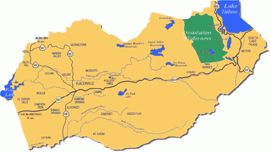
The Fire District is located in the Mother Lode along the U.S. Highway 50 corridor between Sacramento and South Lake Tahoe, California. Lying on the western slope of the Sierra Nevada mountain range, the District includes a diverse service area of grassy foothills, brush-covered valleys, rural communities, commercial corridors, and heavily timbered mountain areas.
The District’s service area begins in the lower foothills near Salmon Falls and extends east into the Sierra Nevada near Twin Bridges, with elevations ranging from approximately 500 feet to more than 6,000 feet. Many of the homes and communities protected by the District are located within wildland-urban interface areas.
Following the reorganization of the Diamond Springs–El Dorado Fire Protection District into the El Dorado County Fire Protection District, the District now serves approximately 346 square miles and provides fire protection, rescue, emergency medical services, fire prevention, and community risk reduction services to a population of more than 85,000 residents.
Situated near the center of the District is the City of Placerville, the county seat, along with the historic communities of Diamond Springs and El Dorado. Together, these communities reflect the District’s mix of small-town neighborhoods, rural residential areas, commercial centers, agricultural lands, and Sierra Nevada recreation corridors.
The El Dorado County Fire Protection District is an independent special district governed by a locally elected seven-member Board of Directors. The Fire District is not a city, county, or state government agency.
The District operates staffed and reserve fire stations throughout its service area and participates in the Western Slope El Dorado County Emergency Services Authority to provide Advanced Life Support ambulance service to the region.
For a map of all fire districts in El Dorado County visit the El Dorado County GIS Hub.